The Project.
The Cold War in Guatemala was a deeply spatial and territorial project that involved heated struggles over territory and sovereignty, as well as the scales of the hemisphere, nations, regions, and towns. Geographic knowledges were crucial to all parts of the Cold War – from efforts to build viable nation-states through large-scale development, to armed insurgents guerrilla strategy, and counter-insurgency scorched earth campaigns. Crucial to military and state efforts were detailed and accurate maps, built upon geodetic data, land surveys, aerial photography, and satellite imagery. On the other hand, insurgents often relied upon a combination of state-produced maps and local and Indigenous knowledge. They relied upon mobile landscapes, that contrasted state efforts to fix locations, and sought to avoid the eyes of the state.
The Latin American Cold War was waged in places, and we cannot understand what happened without understanding how those geographies were known, imagined, and lived by its Indigenous peoples over time.
There are two facets to this project. Cold War Cartographies seeks to reveal how geographic knowledges shaped the contours of insurgency, counter-insurgency, and development in one of the most pivotal countries in the Latin American Cold War. This facet of the project focuses on state cartographic efforts during the Cold War and the military and developmental uses of cartographic technologies. It reveals how these geographic knowledges shaped both megadevelopment projects including the hydro-electric dams and mines, and counter-insurgency campaigns. Cold War Cartographies draws on over two dozen oral histories and research in 13 different archives.
The second facet of this project, Komon Sajb’ichil, is a deep collaboration between Julie Gibbings (PI), Feliciana Herrera Sitp’op (Co-I, Ixil Maya), Alejandro Flores Aguilar (Postdoc), the Ixil Ancestral Authorities, and the Ixil University, as well as eight Ixil researchers.
The Komon Sajb’ichil is a communal ritual that begins every spring, when it is time to plant a new field of maize. Upon the request of an Ixil family, the entire community works in rotation through the night to complete ancestral ceremonies until the sajb’ichal (new dawn), when the whole community awakens to plant corn. This is a communal labour rooted in Maya principles of solidarity and reciprocity to cultivate a new beginning and ensure prosperity for all.
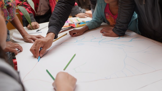
Grounded in the theory and method of Komon Sajb’ichil, our collaborative research project seeks to remember Ixil cartographies – the ways they navigated, understood, and represented places – in the midst of insurrection, state terror, exile, and refuge, to prepare for a new future.
A principal outcome of this project is a series of Ixil-researched and produced memory maps hosted on this page. By seeking to recover Ixil histories and memories of the places where the war was waged, this project recognised intergenerational knowledge and sharing as the keys to communal justice and healing. This research is timely: all three municipalities that compose the Ixil region are beginning legal processes to recover territories lost during Guatemala’s internal conflict.
This research was funded through an Arts and Humanities Research Council (AHRC) grant and a fellowship. Komon Sajb’ichil (New Dawn through Community): is a collaborative research project with the Ixil Ancestral Authorities, Ixil University, and AVANSCO funded through the Indigenous Partnerships grant of the AHRC. Cold War Cartographies was funded through an AHRC research, engagement and development fellowship.
Methodology
Read more about the methodologies employed in this project in more detail.
Methodologies >